Age Class Process
Age class process detects forest stand age in order to predict when clearfell harvesting will happen at any time in the future.
Investigation
The North and South Island regions' plantation forest extents were primarily based on LCDB V5.0 (as mapped in 2018), supplemented with missing areas identified through the NZ Topo 1:50k Exotic Forest dataset, ensuring a minimum contiguous feature size of 3 hectares. This minimum area was selected to reduce dataset complexity and to ensure sufficient data would be available to give an accurate age class estimate.
The age classing process utilised LiDAR for base predictions, with the Hansen Global Forest Change data used instead where possible (change had occurred post-2000). The LUCAS NZ Forest Clearing data was used to fill any remaining gaps. Finally, any additional harvest was detected using Sentinel-2. Additional refinements included grouping LiDAR results into three-year buckets, smoothing internal boundaries, and applying 2023 regional boundaries, ensuring a minimum internal feature size of 1.5 hectares.

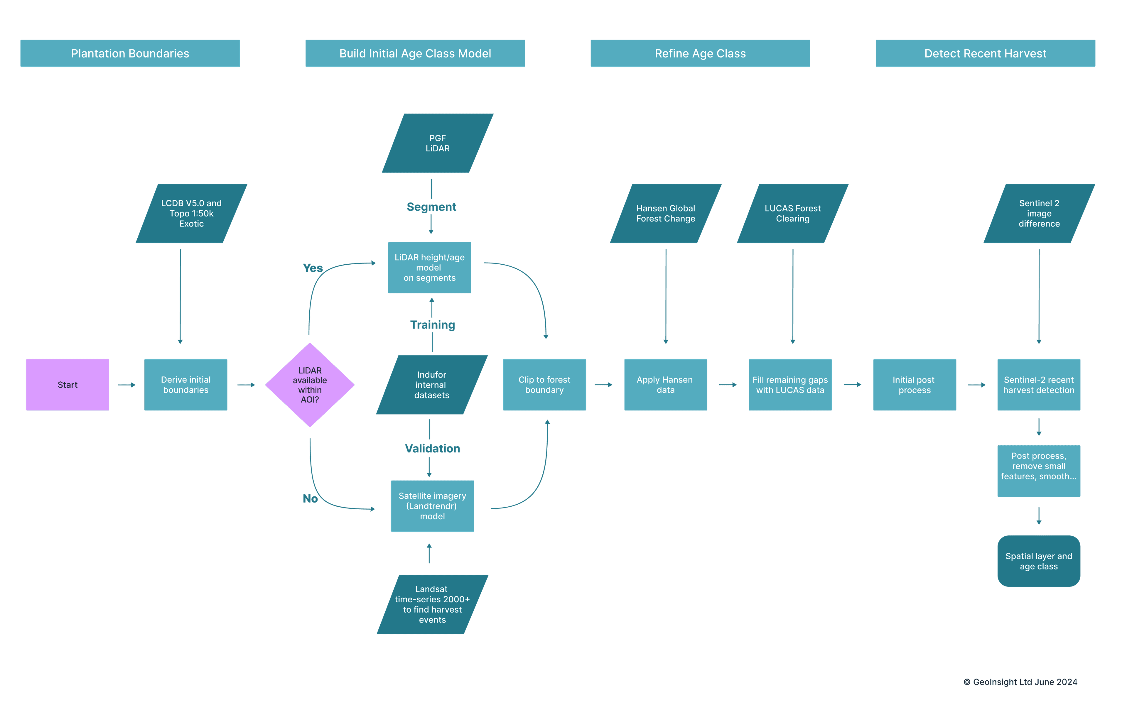
The accuracy of the age class predictions was assessed by reviewing the Landsat time series of points randomly distributed within the forest area with the user-assessed value, which was then compared against the estimated value produced by the age class process for the coincident forest unit. Approximately 600 points were assessed across the target regions, split evenly between the North and South Islands.
North Island Results
The combined accuracy of the age class estimates for the Gisborne and Hawkes Bay regions was 71% of sample point age was estimated within a year of actual stand age, 83% within two years of actual stand age and 87% within three years of actual stand age, after post-processing was applied. Notably, the estimates based on harvest detection (Hansen V1.10 and Sentinel-2) were more accurate than the LiDAR-derived results. Stand age for 92% of points estimated using Hansen or Sentinel-2 were within a year of actual stand age, while this dropped to 41% for LiDAR estimates, although 75% of LiDAR points were within three years of actual stand age. The split between the two stand age sources was relatively even, with 59% using Hansen and Sentinel and 41% using LiDAR.

South Island Results
The combined accuracy of the age class estimates for the Nelson, Marlborough and Tasman regions was 86% of sample point age was estimated within a year, 93% within two years and 94% within three years, after post-processing was applied. The improvement relative to the North Island results was due to the greater proportion of results that we estimated using the Hansen model and Sentinel-2 (which had a similarly higher degree of accuracy compared to the LiDAR-derived age-class results as the North Island) which thus improved the overall accuracy. About 80% of the age-class QC points were estimated with this data, while the remaining 20% were classified using LiDAR. This difference in proportions between the North and South Islands likely highlights the younger resource age in the South Island, resulting in a greater number of features having a change post 2000 which was then captured by the satellite imagery based data sources.

Example Output
An example of the final output for stand age-class estimations for the South Island with a Sentinel-2 basemap. Of note are the recent plantings, which are generally captured with Hansen and Sentinel-2, and the earlier, pre-2000 areas which were estimated using LiDAR. Where there are clear edges between harvest and remaining mature forest, the internal boundaries can be quite accurate despite the generalisation and smoothing processes that were applied.
The decision to exclude small woodlots from the current display of information was made to simplify data complexity. This approach also impacts the age classification process; smaller features, such as small woodlots, receive fewer LiDAR and satellite data 'hits,' which complicates the estimation of their age. The age classification relies heavily on the capture date of the imagery used for harvest detection.

Assembled Datasets
| Data Source | Region | Category | Data | License | Citation |
|---|---|---|---|---|---|
| Marlborough LiDAR 1m (2018) | Marlborough | LiDAR | Link | CC BY 4.0 | Marlborough District Council, LINZ (2019). Marlborough, New Zealand 2018. Collected by AAM New Zealand Limited, distributed by OpenTopography and Land Information New Zealand (LINZ). https://doi.org/10.5069/G91R6NNG. Accessed: 2023-11-30 |
| Marlborough LiDAR 1m (2020-2022) | Marlborough | LiDAR | Link | CC BY 4.0 | Marlborough District Council, Toitū Te Whenua Land Information New Zealand (LINZ) (2023). Marlborough, New Zealand 2020-2022. Collected by Aerial Surveys, distributed by OpenTopography and LINZ. https://doi.org/10.5069/G97D2SBO. Accessed: 2023-11-30 |
| Tasman Bay LiDAR 1m (2022) | Tasman | LiDAR | Link | CC BY 4.0 | Tasman District Council, Toitū Te Whenua Land Information New Zealand (LINZ) (2023). Tasman Bay, Tasman, New Zealand 2022. Collected by Aerial Surveys, distributed by OpenTopography and LINZ. https://doi.org/10.5069/9N29V5H. Accessed: 2023-11-30 |
| Gisborne LiDAR 1m (2018-2020) | East Coast | LiDAR | Link | CC BY 4.0 | Gisborne District Council, LINZ (2021). Gisborne, New Zealand 2018-2020. Collected by Aerial Surveys, distributed by OpenTopography and Land Information New Zealand (LINZ). https://doi.org/10.5069/G92V2D9X. Accessed: 2023-11-30 |
| Hawke's Bay LiDAR 1m (2020-2021) | Hawke's Bay | LiDAR | Link | CC BY 4.0 | Hawke's Bay Regional Council, Wairoa District Council, Napier City Council, Central Hawke's Bay District Council, Toitū Te Whenua Land Information New Zealand (LINZ) (2023). Hawke's Bay, New Zealand 2020-2021. Collected by Ocean Infinity, distributed by OpenTopography and LINZ. https://doi.org/10.5069/G9S75DH2. Accessed: 2023-11-30 |
| Golden Bay LiDAR 1m (2017) | Tasman | LiDAR | Link | CC BY 4.0 | LINZ (2018). Golden Bay, Tasman, New Zealand 2017. Collected by AAM New Zealand Limited, distributed by OpenTopography and Land Information New Zealand (LINZ). https://doi.org/10.5069/G9N877WS. Accessed: 2023-11-30 |
| Tasman LiDAR 1m (2020-2022) | Tasman | LiDAR | Link | CC BY 4.0 | Tasman District Council, Toitū Te Whenua Land Information New Zealand (LINZ) (2023). Tasman, New Zealand 2020-2022. Collected by Aerial Surveys, distributed by OpenTopography and LINZ. https://doi.org/10.5069/G9S46Q5N. Accessed: 2023-11-30 |
| Motueka River Valley 1m (2018-2019) | Tasman | LiDAR | Link | CC BY 4.0 | Tasman District Council, LINZ (2020). Motueka River Valley, Tasman, New Zealand 2018-2019. Collected by Aerial Surveys, distributed by OpenTopography and Land Information New Zealand (LINZ). https://doi.org/10.5069/G9D21VRX. Accessed: 2023-11-30 |
| Abel Tasman and Golden Bay LiDAR 1m (2023) | Tasman | LiDAR | Link | CC BY 4.0 | Tasman District Council, Toitū Te Whenua Land Information New Zealand (LINZ) (2024). Abel Tasman and Golden Bay, Tasman, New Zealand 2023. Collected by Aerial Surveys, distributed by OpenTopography and LINZ. https://doi.org/10.5069/G94M92SX. Accessed: 2024-03-04 |
| Nelson LiDAR 1m (2021) | Nelson | LiDAR | Link | CC BY 4.0 | Nelson City Council, Toitū Te Whenua Land Information New Zealand (LINZ) (2021). Nelson, New Zealand 2021. Collected by Aerial Surveys, distributed by OpenTopography and LINZ. https://doi.org/10.5069/G9R78CD4. Accessed: 2023-11-30 |
| Hansen Global Forest Change V1.10 (2000 to 2022) | All | Landsat Change Detection | Link | CC BY 4.0 | Hansen Global Forest Change sourced from the Google Earth Engine Data Catalog and licensed for reuse under the CC BY 4.0 licence. Hansen, M. C., P. V. Potapov, R. Moore, H. Hancher, S. Turubanova, A. Tyukavina, D. Thau, S. V. Stehman, S. J. Goetz, T. R. Loveland, A. Kommareddy, A. Egorov, L. Chini, C. O. Justice, and J. R. G. Townsend. 2013. High-Resolution Global Maps of 21st-Century Forest Cover Change. Science 342 (15 November): 850-853. Data available online from: https://glad.earthengine.app/view/global-forest-change. |
| LUCAS NZ Forest Clearing 2008-2020 V019 | All | Aerial Change Detection | Link | CC BY 4.0 | ANZLIC LUCAS NZ Forest Clearing 2008 2020 v019 by Ministry for the Environment sourced from the MfE Data Service and used under the Creative Commons Attribution 4.0 International licence. |
| LCDB v5.0 - Land Cover Database version 5.0, Mainland, New Zealand | All | Boundaries | Link | CC BY 4.0 | LCDB v5.0 Sourced from the LRIS portal and licensed for reuse under the CC BY 4.0 license. Data was modified. |
| Site Index | All | Productivity Surface | Link | Productivity Prediction Tool Licence | Watt, M.S., Palmer, D.J., Leonardo, E.M.C, Bombrun, M. (2021) Use of advanced modelling methods to estimate radiata pine productivity indices. Forest Ecology and Management, 479, 118557. |
| Regional Council 2022 (generalised) | All | Boundaries | Link | CC BY 4.0 | This work is based on/includes Stats NZ's data which are licensed by Stats NZ for reuse under the Creative Commons Attribution 4.0 International licence. |
| Sentinel-2 Level 2A | All | Imagery | Link | Link | Contains modified Copernicus Sentinel data, 2022 to 2024, processed in Google Earth Engine |
| Landsat Collection 2 | All | Imagery | Link | Link | Landsat 4, 5 ,7 8 and 9 images courtesy of the U.S. Geological Survey |
| NZ Coastlines and Islands Polygons (Topo 1:50k) | All | Boundaries | Link | CC BY 4.0 | Coastline data sourced from the LINZ Data Service and licensed for reuse under the CC BY 4.0 licence. Data was modified. |
| NZ Exotic Polygons (Topo, 1:50k) | All | Boundaries | Link | CC BY 4.0 | NZ Exotic Polygons (Topo, 1:50k) data sourced from the LINZ Data Service and licensed for reuse under the CC BY 4.0 licence. Data was modified. |
| Regional Council 2023 Clipped (generalised) | All | Boundaries | Link | CC BY 4.0 | This work is based on or includes Stats NZ’s data which are licensed by Stats NZ for reuse under the Creative Commons Attribution 4.0 International licence. |
Indufor